Cape Breton Island is located on the eastern tip of Nova Scotia, Canada. The island of 10,311 km sq. (3,981 square miles) occupies 18.7% of the total area of Nova Scotia. The eastern and southern coasts border the Atlantic Ocean, and its eastern coast forms the western boundary of the Cabot Strait. The Strait of Canso separates the island from the Nova Scotia peninsula, although the 1,385 m (4,544 ft) long rock-fill Canso Causeway joins it to mainland Nova Scotia. Bras d’Or (French for “Golden Arm”), one of the largest saltwater lakes in the world, occupies the center of the island.
- History of Cape Breton Island
- Know About Cape Breton Island’s Geography
- Economy
- 17 Surprising and Wonderful Facts about Cape Breton Island
- 1. How Cape Breton got its name and its total area!
- 2. Initial Inhabitants of the Island
- 3. Know About Cape Breton Population
- 4. Cape Breton Island’s Geology
- 5. Some Important Geographical Aspects of Cape Breton
- 6. A Glimpse of Cape Breton Island Nature’s Beauty
- 7. Also Known for Whale Migration
- 8. Center of the World’s Largest Saltwater Lake: Bras d’Or Lake
- 9. Sydney Port is one of the largest Commercial Centers on the Cape Breton Island
- 10. Enjoy the Local Music of the Island
- 11. Home to Two Major Coal Mines on the Island
- 12. Awarded as North America’s Number one Island By the Condé Nast Travel Guide
- 13. More to Learn about Island’s Ecology System and Habitat
- 14. Island Run by Cape Breton Regional Government
- 15. Know More about Island’s Reserves
- 16. Whale Watching: A Popular Tourist Attraction
- 17. Highlights of Skyline Trail
- Visit Historic Sites
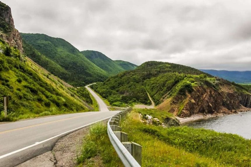
- 1. The Cabot Trail
- 2. Cape Breton Highlands National Park
- 3. Alexander Graham Bell National Historic Site
- 4. Fortress of Louisbourg National Historic Site
- 5. St. Peters Canal National Historic Site
- Things To Do In Cape Breton Island
Cape Breton is known for its beauty, scenic view, hiking trails, spectacular coastal vistas, highlands, and many more. If you plan to take a trip to Cape Breton, you must know some interesting and amusing facts about Cape Breton, which will make your journey more exciting and more happening. Let’s explore Canada’s Best Kept Secret- Cape Breton a little more.

History of Cape Breton Island
The initial inhabitants of Cape Breton Island were most likely archaic marine natives, predecessors of the Mi’kmaq people. These peoples and their descendants have lived on the island ( Unama’ki) for thousands of years and still live today. Because of the poor agricultural conditions in their coastal location, their traditional way of life revolved around hunting and fishing.
In 1497, Italian explorer John Cabot was said to have reached the island. However, the quality of European history and maps from the period makes it impossible to say whether Cabot visited Newfoundland or Cape Breton Island first. The Cabot Trail in Cape Breton and the Cabot’s Historic Site & Provincial Park close to Dingwall are both named after this discovery.
Île Royale
Earlier known as Île Royale island or often called Royal Island by the French people, was first settled by France; the island was actively settled by France. After the French handed over their claims to New Fundland and mainland Acadia to Britain under the Treaty of Utrecht signed in 1713, the French moved the Pleasance population of New Fundland to Ile Royal, and the French garrison in the eastern central part was Built in Saint An.
In 1734, the French built the Louisbourg Lighthouse. It was the first lighthouse in Canada and one of the first lighthouses in North America. The French colony of Île Royale also contained Île Saint-Jean and Les Îles-de-la-Madeleine, afterward renamed Prince Edward Island, in addition to Cape Breton Island.
Colonies of Nova Scotia
The British government divided Nova Scotia into three provinces, namely New Brunswick, Cape Breton Island, and Peninsular Nova Scotia, along with its neighboring colonies of St. John’s Island and Newfoundland. Sydney, the capital of Cape Breton Island, is situated on its eponymous harbor, overlooking Spanish Bay and the Cabot Strait.
Cape Breton Island and Prince Edward Island were amalgamated with Nova Scotia for the next time in 1820; however, Prince Edward Island was afterward taken from Nova Scotia’s control. This was one of the leading causes that led to industrial growth in the Sydney Coal Field of eastern Cape Breton County. In the latter half of the 19th century, because of quicker shipping, an increase in fishing, and the development of the island, human exchanges among the islands of Newfoundland and Cape Breton increased, kicking off cultural changes that maintain still today.
By the 20th century, Cape Breton Island was started known for its scientific development through the activities of the inventors Alexander Graham Bell and Guglielmo Marconi.
Know About Cape Breton Island’s Geography
The unevenly shaped rectangular island is approximately 100 kilometers wide and 150 kilometers long, with a total size of 10,311 square kilometers (3,981 square miles). It’s in the southeast part of the Gulf of St. Lawrence. The narrow Strait of Canso separates Cape Breton from the Nova Scotia peninsula region. The Canso Causeway connects the island to the mainland. Rocky coasts, undulating farms, glacial valleys, desolate headlands, hills, woodlands, and plateaus make up Cape Breton Island.
-
Climate
The closeness of the cold, often arctic Labrador Current and its warmer counterpart, the Gulf Stream, both prominent currents in the North Atlantic Ocean, moderates the mild summer humid continental climate.
-
Ecology
Cape Breton ecology includes Lowland Areas, Hills of Cape Breton, Cape Breton highlands, and plateau and coastal areas.
Lowland areas near Lake Ainslie, the Bras d’Or watershed, Boularderie Island, and the Sydney coalfield on the western shore. The Hills of Cape Breton environment may be found all across Cape Breton. It is characterized as hills and slopes between 150 and 300 meters above sea level that are typically covered by Acadian forest. North Mountain, Kelly’s Mountain, and the East Bay Hills are all part of it.
The Highlands includes northern parts of the counties of Inverness and Victoria. Cape Breton coastal, including the eastern shore, has a peaceful and cool environment with rain and fog, wind waves, and cool summer temperatures. A glacial forest of black spruce and balsam fir dominates the landscape. Hardwoods like white birch and red maple thrive in sheltered places. There are a lot of salt marshes, fens, and bogs there.
Economy
Much of Cape Breton Island’s recent economic history may be related to the coal industry. There are two significant coal deposits on the island. The Sydney coalfield, located in the southeastern portion of the island along the Atlantic Ocean, supported Cape Breton’s industrial economy in the 19th and 20th centuries. The Inverness coalfield in the western part of the island along the Gulf of St. Lawrence is reasonably small but has several mines. Sydney has historically been the main port, with various facilities and services in a big, protected natural harbor. The Marine Atlantic terminal in North Sydney serves as the departure point for large ferries to Channel-Port aux Basques and, seasonally, Argentia on the island of Newfoundland.
With the closure of the Cape Breton Development Corporation’s (DEVCO) coal mines and the Sydney Steel Corporation’s (SYSCO) steel mill, the industrial Cape Breton area faced several challenges. In recent years, island residents have sought to diversify their local economies by investing in tourism development, call centers, SMEs, and manufacturers in auto parts, pharmaceuticals, and windowpanes.
Here are 17 surprising and amusing fun facts about Cape Breton Island. Let’s check out all of these facts before planning to take a trip to Cape Breton Island.
17 Surprising and Wonderful Facts about Cape Breton Island
1. How Cape Breton got its name and its total area!
Cape Breton Island is named after its easternmost point Cape Breton. The 10,311 square kilometers island occupies 18.7% of Nova Scotia’s total area.
2. Initial Inhabitants of the Island
The initial inhabitants of Cape Breton Island were most likely archaic marine natives, predecessors of the Mi’kmaq people. For thousands of years, these people and their descendants have lived on the island (Unama’ki) and still live today.
3. Know About Cape Breton Population
About 75% of the Cape Breton island’s population covers the entire Cape Breton County and lives in the Cape Breton Regional Municipality (CBRM), known as Industrial Cape Breton Region.
4. Cape Breton Island’s Geology
The rectangular, irregularly shaped island is about 100 kilometers wide and 150 meters long and covers 10,311 square kilometers. It is located at the southeast end of the Gulf of St. Lawrence.
5. Some Important Geographical Aspects of Cape Breton
The island lies east-northeast of the mainland, with its northern and western coasts facing the Gulf of St. Lawrence with the west coast forming the eastern limits of the Northumberland Strait.
Cape Breton is separated from mainland Nova Scotia by the intense Canso Strait. The island is connected to the mainland by the Canso Causeway. Cape Breton Island comprises rocky shores, rolling farmland, glacial valleys, arid headlands, highlands, forests, and plateaus.
6. A Glimpse of Cape Breton Island Nature’s Beauty
Cape Breton Island gives you a glimpse of the scenic beauty of the Cabot trail, recreational activities including outdoor adventure, coastal adventure, hiking trails, boating Bras d’Or Lake, camping, flying fishing, motorcycling, and many more.
7. Also Known for Whale Migration
The Cape Breton Highlands National Park Skyline Trail Hiking Trail overlooks the Gulf of St. Lawrence, known for its whale migration.
8. Center of the World’s Largest Saltwater Lake: Bras d’Or Lake
The island’s center is dominated by Bras d’Or lake (“Arm of Gold” in French), one of the world’s largest saltwater lakes.
9. Sydney Port is one of the largest Commercial Centers on the Cape Breton Island
Sydney has always been a crucial port, as it offers a lot of facilities to a vast, protected, and natural harbor. The island’s most prominent commercial center is the site of the Cape Breton Post daily newspaper, and also a television station, CJCB-TV, and many radio stations.
10. Enjoy the Local Music of the Island
The city of Sydney celebrates local music with a giant waterfront fiddle statue, the Big Fiddle.
11. Home to Two Major Coal Mines on the Island
The Island consists of two main coal mines
#1. The Sydney coalfield, located in the southeastern part of the island along the Atlantic Ocean, supported Industrial Cape Breton Economy in the 19th and 20th centuries.
#2 The Inverness coalfield in the western part of the island along the Gulf of St. Lawrence
12. Awarded as North America’s Number one Island By the Condé Nast Travel Guide
In 2019, Condé Nast Traveler readers rated Cape Breton Island as North America’s Number 1 Island and the number 1 island in Canada by Travel + Leisure readers. These honorable awards make the island one of the best travel island destinations in the world.
13. More to Learn about Island’s Ecology System and Habitat
Cape Breton Ecology includes lowland areas along the western coast, around Lake Ainslie, the Bras d’Or lake, Boularderie Island, and the Sydney coalfields, Cape Breton hills, including North Mountain, Kelly’s Mountain, and East Bay hills that covered the Acadian forest, Highlands and the North Plateau, and Cape Breton Coastal.
14. Island Run by Cape Breton Regional Government
Local government on the island is provided by Cape Breton Regional Government, Inverness County, Richmond County, and Victoria County, as well as the City of Port Hawkesbury
15. Know More about Island’s Reserves
The island has five Indian Miꞌkmaq reserves: Eskasoni, Membertou, Wagmatcook, Waycobah, and Potlotek. Eskasoni is the largest reserve in terms of both population and area.
16. Whale Watching: A Popular Tourist Attraction
The most famous attraction for tourists is underwater rather than on land. It is Whale watching. Whale watching cruises are run by many operators belonging to Baddeck and Cheticamp. The most famous whale species in Cape Breton’s waters is the short-finned pilot whale.
17. Highlights of Skyline Trail
Skyline trail highlights the panoramic view of the Northumberland Strait, winding Cabot Trail, and Cape Breton Highlands, located within Cape Breton Highlands National Park. Interpretive panels also highlight the trail’s Vegetation and Wildlife.
Visit Historic Sites
1. The Cabot Trail

The Cabot Trail is a picturesque road course around Cape Breton Highland and beyond, with spectacular coastal views. Every summer and autumn, more than 400,000 visitors ride the Cabot Trail. In connection with the Fortress of Louisbourg, it has helped the island’s tourism industry grow over the past few decades. Condé Nast Travel Guide ranks Cape Breton Island as one of the top island destinations in the world.
2. Cape Breton Highlands National Park

The 950-square-kilometer Cape Breton Mountains National Park protects spectacular highlands and coastal wilderness. A tall, flat-topped plateau dominates the park, carved deeply by river canyons. Cape. Any Park facility needs an admission permit, including the Cabot Trail touring within the Park, the Keltic Lodge, and the Highlands Links.
There are 26 trails with panoramic views of the canyons, highlands, and coast. Cycling, hiking, fishing, golf, kayaking, canoeing, and swimming are one of the activities available in the park, with many beaches, picnic areas, and campgrounds. Cape Breton Highlands National Park will open from May 20 to October 23, 2022, this year. The Cabot Trail is open all year round.
Hope you enjoy the Cape Breton Highlands national park, a truly breathtaking section of the winding Cabot Trail.
3. Alexander Graham Bell National Historic Site

The Alexander Graham Bell National Historic Site is a 10-hectare property overlooking the Bras d’Or Lakes in Baddeck, Cape Breton, Nova Scotia, Canada. The Alexander Graham Bell National Historic Site, which houses the most enormous storehouse of artifacts and documentation from Bell’s years of experimental work in Baddeck, is part of Parks Canada’s national park system. In 1952, the property was recognized as a National Historic Site.
4. Fortress of Louisbourg National Historic Site

The Fortress of Louisbourg (Forteresse de Louisbourg) is a National Historic Site in Louisbourg, Nova Scotia. France built it as important fishing, transshipment, and supply port for its maritime empire. Visit The Reconstructed town, Mi’kmaw Interpretive Centre, Enjoy walking trails, bird watching, explore beaches and mountain hiking, picnicking, and many more.
5. St. Peters Canal National Historic Site

The St. Peters Canal is a small shipping canal on Cape Breton Island in eastern Canada. The 800-meter canal built on an isthmus, St Peters canal connects the Atlantic Ocean with the sparkling Lake Bras d’Or lake and meanders the famous Battery Park for boating, fishing, and picnics.
The canal’s history can be traced back to a fortified 17th-century trading post built by French merchants. Its unique 15-year construction and evolution as a modern waterway opened up Cape Breton Island development. The St. Peter’s Canal is no longer used for commercial transport on Cape Breton Island, but it is a crucial waterway for pleasure craft. The Industrial Cape Breton Area faced several challenges due to the closure of the Cape Breton Development Corporation (DEVCO) coal mine and the Sydney Steel Works (SYSCO). One can enjoy several activities like boating activities on Bras d’Or lake, fishing, camping, and so much more.
Things To Do In Cape Breton Island
The trails, mountains, and coastal areas offer several outdoor activities and adventures. Let’s explore the activities that one can enjoy on this beautiful island.
#1. Camping
Snuggle up to a wooded oasis or seaside retreat surrounded by wind and wildlife. It includes more than 25 private campgrounds on the island, 3 state campground parks, and 6 magnificent Cape Breton Highlands National Park campgrounds, perched high on shore-lined slopes or miles below a canopy of ancient woods.
#2. Hiking Trails
Cape Breton Island is a hiker’s paradise, with a rugged beauty that begs to be explored. Every Highland peak, low-tide beach, and quiet journey through old-growth woodland will reward you with breathtaking scenery. The hiking paths in the Cape Breton High lands National Park range from moderate strolls to strenuous climbs with panoramic views of canyons, highlands, and seacoasts. The trails allow you to get up close and personal with the unique environment of northern Cape Breton Island. The park’s limits do not mark the end of nature. Many of the adjacent locations have equally beautiful pathways.
Visit several trails, including the Acadian trail, Franey trail, Skyline trail, Louisbourg Lighthouse trail, and many more to explore. One must explore the breathtaking beauty of these trails.
#3. Cycling
This Island has some of the most beautiful cycling routes and trails in North America. Climb the Cabot Trail’s twisting peaks for beautifully colored fall foliage vistas. The Celtic Shores Coastal Trail winds its way down the island’s west coast, passing by beach and boardwalk.
#4. Enjoy Golf
Cape Breton Island was created for golf, with expansive cliffs, magnificent sea views, and miles of greenery. Inspired by the Scottish heritage of the island, designed to complement our stunning terrain, you’ll find courses for every game, from championship courses to Canada’s only accurate links course.
According to National Geographic, Cape Breton Island is a “magic island” with one of the most extensive drives in the world. And over the years, Nova Scotia has become known for offering some of the best, most fascinating golf courses across North America.
#5. Enjoy Celtic Colours Festival
Every year, Cape Breton Island comes alive with the best Celtic musicians worldwide. During the Celtic Color International Festival, Concerts are held everywhere, one of Canada’s major music events. From the minor halls to the largest arenas in the community, you can see world-class musicians sharing the stage with the island’s best singers, dancers, performers, and storytellers.
Cape Breton Island is home to the world-famous Cabot Trail, Highlands National Park, National Historic Sites, dramatic coastal view, plateau scenery, Lake Bras d’Or lake, various hiking trails, world-class golf, Celtic Culture, vibrant traditional music, and so much more.
The Cabot Trail takes you on a journey that you’ll want to repeat time and time!

Last Updated on by Priyanshi Sharma