The Trent-Severn Waterway is a 386 kilometres long canal across Central Ontario, connecting Georgian Bay and Lake Huron at Port Severn, linking the Bay of Unite.
It is a natural and human-made waterway that includes Trent River, Kawartha Lakes, Otonabee River, Lake Simcoe, Lake Coaching, and Severn River.
Trent-Severn Waterway National
The Trent-Severn Waterway is a Historic-site of Canada that is managed and regulated by Parks- Canada. In 1972, the Trent-Severn Waterway was included in the National Historic sites of Canada to attract tourists worldwide.
Overview of the Trent–Severn Waterway
The Trent-Severn Waterway is a part of Canada’s national canal system that stretches over the city of Quinte West on Lake Ontario’s Bay of Quinte in the south, to faraway Georgian Bay on Lake Huron.
It begins at Trenton, Ontario, with human-made channels roughly measuring 32kms; and has over 40 locks, including 36 regular locks, 2 sets of flight locks, and hydraulic lift locks at Kirkfield and Peterborough, which is unique in North America.
It also has a sea railway at Big-Chute, lock 44, which transports boats between the upper and the lower sections of the Trent-Severn Waterway.
The system comprises 160 dams, 39 swing bridges, and other structures that effectively control the water level and flood control.
In Balsam Lake, it reaches its highest point at approx. 256.3 meters and a length of 406 meters at the summit of the Rhine-Main-Danube Canal of North America, with a fall of 80 meters to Lake Huron.
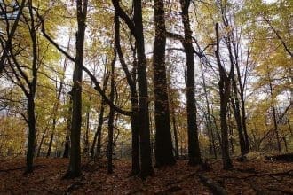
The Trent-Severn Waterway is well known for its beauty and unique picturesque over various sections of its route like the Hydro Glen or the Sparrow Lake. It is also called the “finest interconnected systems of navigation in the world” by Parks-Canada.
Why and When Was the Trent-Severn Waterway Built?

The Trent-Severn Waterway building began constructing small dams and water-powered mills during the late 18th Century at various South Central Ontario locations.
Logging, milling, recreation, and grain handling helped develop the Trent-Severn Waterway. At the start of the 19th Century, the Logging Industry’s emergence added to the number of dams to facilitate the floating of the timber slides cut from the forests. And to move the logs for shipment to Great Britain and the United States.
Earlier, the now modern Trent-Severn Waterway’s land river route was used by the nation to travel between the Kawarthas and Huron and Ontario’s lakes.
The desire to covert the channel into a navigable waterway that provides a communication route from Lake Ontario to Georgian Bay emerged gradually with the expansion of the settlement in Upper Canada and the opening of the War of the First Coalition in 1793; while moving people and goods between the United States and lower and the upper part of Canada was thought to be strategically prudent.
To solve the problem, John Graves Simcoe began the construction of Yonge Street and the Penetanguishene road that would serve as an overland portage route to Georgian Bay via Lake Simcoe and bypass all the choking points on the way.
The road, however, wasn’t of much use until 1816 due to its narrow area. For a long time, the military used the route as a naval depot for shipments, mainly during the wars.
The lack of convenient use of the upper lakes demanded the use of the inland waterways for military purposes, which led to many canals that provided access to the Upper Canada area.
Various locks and dams permit the navigation between Kawartha Lakes and various other stretches of the Trent River. In 1883, the Trent-Severn Waterway lock was constructed at Bobcaygeon by the Inland Water Commission.
It constituted the beginning of the improvement of the Trent-Severn Waterway connecting Lake Ontario with Georgian Bay.
The Trent-Severn Waterway construction was completed in the year 1920, after 87 years. After constructing all the dams and the locks, the canal linking Georgian Bay and Lake Simcoe along the Severn River was formed.
The canal initially lacked in many areas after its completion. It failed to affect the economy of the regions it proposed to serve.
The paths were designed for the boats that got obsolete and were too small to be commercially viable. The railways were also being developed to change railway patterns and networks.
The Trent-Severn Waterway finally became obsolete for commercial purposes, with the present-day Well and Canal’s completion in 1932. The latter could handle ships large enough to sail across the ocean.
Trent-Severn Waterway–A Tourist Spot

The Trent-Severn Waterway is now operated by the national park service Parks-Canada and is used as a tourism and recreational spot for boaters. Many famous cruise lines operate ships and houseboats rental firms.
The Trent-Severn Waterway is now used for boating, hydroelectric power generation, wildlife habitat protection, and flood control.
The principal heritage value of the Trent-Severn Waterway lies in the completeness of its transportation route. This has been embodied with many engine structures such as locks, dams, buildings, and bridges linked to the Trent-Severn Waterway.
The Peterborough lift Lock is of great importance and has been acknowledged ever since it was built. It was once reputed for being the highest concrete structure in the world. The Lift Lock was built in the year 1904.
The Dominion Bridge of Montreal is considered significant. The Lake Simcoe- Balsam Lake section of the Trent-Severn Waterway is also valued much for its surviving fundamental structures ever since its construction period 1900-1907.
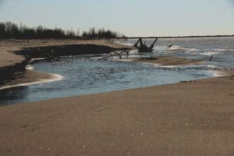
The Trent River widens from Lock 18 at Hastings leading into Rice Lake. Rice Lake is one of the largest lakes on the Trent–Severn system, named after the rice cultivation by the Indians.
The rice crops grew over 3 feet above the water level, cultivated by the early settlers. In recent days, it has ended because of the changes in the pattern of the river.
Otonabee river is short and is made of two different rivers. The upper portion runs from Katchiwanooka Lake to Peterborough’s Little Lake and is surrounded by limestones and cedar-lined shores.
The lower level travels along treed shorelines to Rice Lake. Canada is also famous for several other attractions like Abraham Lake, Moraine Lake, and Waterton Lakes National Park. And Other national parks.
Water Management of The Trent Severn Waterway
The Trent-Severn waterways operations faced the water management challenge for a very long time. The dams built to facilitate navigation could not keep up with the seasonal fluctuations of the water levels.
The high spring freshet’s water levels dropped gradually to 2 cm a day, with too much lower levels through evaporation during the summer seasons. In most sections, the water levels declined to a much lower than the minimum navigation level.
The need for a reservoir system was recognized by the mid-19th Century; that would let the rivers and lakes of the primary system recharge and allow smooth navigation during the summer days.
The dams in the reservoir lake are sequentially adjusted by a Haliburton-based crew that travels by boat to reach the dams spread over a large geographic area.
The barriers make up the central part of the reservoir, adjusted to maintain the water levels by regulating the water flows. With the requirement to adjust the levels and flows, the lock staff adds or removes the stop logs and modifies the hydraulic dams.
The atmosphere here is welcoming on both the water and the town of Kawartha Settler’s Village. The town was established in 1990 to preserve the culture and history of this place. It is a 10-acre site featuring restored pioneer buildings, attractions, and special events for children and adults.
The famous Boyd Heritage Museum is another place people enjoy. It showcases various features of the Boyd Gallery and the work of the local artists of the period.
Fenelon Falls
The Falls is a town in Kawartha-Lakes, Ontario, Canada. It is known as the “Jewel of the Kawarthas” and has a permanent population of 1,800 people, increasing in the summer due to tourism and cottaging.
Lock 34 on the Waterway, which connects Sturgeon Lake and Cameron Lake, is located in the Falls. As it is primarily a tourist destination, it is busiest during the summer. The falls’ main street is known as Colborne Street.
The eponymous falls are concealed because the significant road crosses the river immediately upstream; however, the falls can be seen from a local restaurant or a trail on the Fenelon River’s north band.
The falls provide power to a hydroelectric dam, redirecting some water flow.
History
The particular Falls, which has been renamed after the township, was named right after François de Salignac de la Mothe-Fénelon (not to end up being mistaken for the more renowned half-brother of a similar name), who established a mission in the Bay involving Quinté.
The construction of the block between Cameron and Sturgeon lakes began in 1885. In 1874, the village of the Falls was formed. The Victoria Railway reached the Falls in 1876.
The Midland Railway of Canada took over this route in 1880, and it was absorbed into the Grand Trunk Railway (GTR) in 1893.
CN took over the former GTR in 1923, and it operated the line until the 1980 fire that destroyed the McLaren’s Creek bridge near Lindsay, cutting off the Haliburton Subdivision’s northern end.
The railway was abandoned in 1983, and the track was dismantled in 1984. The line was later turned into a public multi-use trail.
Trent-Severn Waterway Fees
Except for the Swift Rapids lock station, the Waterway Historic Site will allow restricted public access and rudimentary services beginning June 1, 2020.
Every tourist or visitor will have only access to the following services and amenities:
- Lockage, boat launches, access points, and mooring sites are all available.
- Green spaces, picnic spots, and parking lots are examples of day-use places.
- Day-use routes with some bicycle access on authorized trails and paths;
- Grounds of the lock station; and
- Improved cleaning techniques will be applied in public restrooms.
Visiting the Waterway National Historic Site will be different from previous visits. Visitors are encouraged to plan ahead of time by visiting the Waterway-National-Historic-Site webpage.
You may check out the FEES for all activities on this website.
Trent-Severn Waterway Trip Planner
This Trent-Severn Waterway Guide will take you through all the necessary information you’ll need before planning a trip.
If you wish to be a passenger along the Trent-Severn Waterway but don’t want to drive yourself, various companies will perform the driving for you:
- Voyageur Tours at the Canadian Canoe Museum — Paddle along the Trent Canal and up and down the Peterborough Lift Lock in a Voyageur Canoe. You ride for 90 minutes for $25 per adult and $19 per child. The boat can easily take up to 20 people, making it ideal for families and work teams looking for a bonding experience.
- Lift Lock Cruises – Take a cruise north or south of Peterborough, with lunch and dinner options. You may sail down the Otonabee River for $64, which includes dinner and a cash bar, or you can take a private charter with a group for fun or a fundraiser. You can ride up the lift lock while having for $52.50 during the day. They also offer a $36.50 autumn colours excursion up to Trent University and back.
- Stoney Lake Cruise – Take the Spirit of the Kawarthas out of Woodview (north of Peterborough) and see the stunning homes and environs where a rising number of celebrities are relocating. The Glass House was constructed into the rock is one of the most notable features. Lunch cruises cost $60 per person, with a Friday BBQ package for $80 and a Saturday night prime rib for $90.
- Kawartha Voyageur – For $2,400 over six days, tour the river between Big-Chute and Peterborough in luxury with comfy accommodation, food, and snacks. Evening activities include bocce ball, skits, readings, guest lecturers, and a quiet night with a book or tablet.
If You Don’t Own a Boat and Want to Be Your Captain
If you don’t have a boat and wish to traverse the Waterway, you can rent a houseboat or a boat.
Keep an eye out for any safety information, tourist regulations, or weather warnings, especially if your journey spans Lake Simcoe or Lake Coaching. Carry a nautical chart as well.
Rent a houseboat: Happy Days Houseboats in Bobcaygeon teaches you how to operate your rental boat with only a driver’s license and a signed waiver.
You must bring your lifejackets, bedding, and amenities. You may explore the Trent-Severn Waterway or simply moor and enjoy your waterside property.
You can also rent kayaks, canoes, or stand-up paddleboards for your trip. Depending on the size of your party and the time of year, rental costs range from $1,300 to $1,700 for the long weekend or from $1,780 to $3,380 for a week.
Rent a boat: Several boat dealers, including Buckeye Marine in Bobcaygeon, Rosedale Marina in Fenelon-Falls, and Peel Marine in Lakefield, provide rentals.
A tank of gas, cleaning fees, a premium on preparing it for you, and a ramp fee for launching may all be included in the rental prices. You should also expect to pay a refundable damage deposit.
Most businesses will also deliver and pick up the boat, so you won’t have to retrace your steps. A TSW permit is only valid for boats under 84 feet in length.
How to Plan Your Trip: The length of each trip is decided by the number of locks on the stretch of Trent-Severn Waterway you are visiting and the amount of traffic passing through the Lock at each point.
It is best to allow extra time and enjoy the surroundings while waiting. Even better, you might find yourself ahead of schedule, allowing you to stay longer over lunch at a favourite restaurant or a new find.
Here are a few ideas:
For a Three-Day Excursion
In case you only have a long weekend or a few days and nights to learn, treat yourself to a leisurely drive between Peterborough and Lindsay lohan.
You’ll have the opportunity to explore the small villages in between while still having hours of free ocean ahead of you.
Another excellent short run is from Port Severn to Kirkfield. There are fewer locks and quieter paths if that’s what you’re looking for.
For a Longer Journey
You can quickly get from: to: for a relaxing five-day trip.
Trenton-Campbellford;
Campbellford-Point;
Young’s Young’s Point-Bobcaygeon;
Bobcaygeon-Orillia (Couchiching);
or Couchiching-Port Severn.
You can complete the entire trip in a motorized boat in five to seven days if you only go one way and make no tourist stops. Parks Canada recommends scheduling a 7 to 10 days in advance for a full tour to appreciate the journey properly.
This includes the time it takes to navigate each of the 45 locks, which is a great adventure in and of itself.
Trent-Severn Waterway Charts
You may find the charts on this website.
Trent-Severn Waterway Permits
The Trent-Severn Waterway and Rideau Canal National-Historic Landmarks of Canada are managed in a number of ways to benefit Canadians.
Natural landscapes and habitats supplement cultural elements and contribute to the Canals’ environmental quality.
Like all other resources maintained by Parks Canada, cultural and natural resources are ordered to safeguard and present the legacy that they represent.
All work on, under, and the bed and seas of the Trent-Severn Waterway’s lakes and waterways require authorization from Parks Europe.
This includes, but is not limited to, installing, restoring, replacing, relocating, and removing docks, boathouses, boat ports, swim rafts, boat lifts, launch security, dock abutments, away from the coast wet slips, marine railroads, and shoreline stabilization, as well as dredging and marine vegetation removal.
Most work on, underneath, and typically the bed of the Trent-Severn Waterway’s lakes and even rivers requires agreement from Parks Nova scotia.
This includes, although is not constrained to, installing, repairing, replacing, relocating, and removing docks, boathouses, boat ports, swim rafts, boat lifts, launch ramps, dock abutments, inland wet slips, marine railroads, shoreline stabilization, as well as dredging and aquatic vegetation removal.
Trent-Severn Waterway Locks
Principal Attractions of the Waterway and the Areas to Explore
The Trent-Severn Waterway is now used for tourism. Every year millions of tourists visit the Trent-Severn Waterway to enjoy the canal’s unique and scenic beauty. Travelers can enjoy the place by houseboats or canoe, bikes, cars, or foot.
The Trent-Severn Waterway has over 40 locks in different regions: the Trent region, Kawartha Region, Simcoe Region, and Severn Region, including the flight lock, lift lock, and a marine railway station.
The locks are designed to raise or lower the boats from one water level to another. On approaching the locks or swing bridges, signals are sent to request entry or open the bridge.

Lock Number 1- Trenton
Trenton is the first Lock in the Trent-Severn Waterway, beginning with a fascinating journey from Lake Ontario through 386km leading to Georgian Bay.
Constructed in 1913, the dam is extremely popular among visitors for its excellent transportation system. The Loyalist Parkway and the beautiful Apple Route are the favourite stopping point for car travellers.
The initial lock station is a fascinating journey from Lake Ontario to Georgian Bay over the 386-kilometre Trent-Severn, the burkha.
Lock 1 is a popular stop for vehicle drivers since it is easily accessible from Highway 401, the Loyalist Parkway, and the picturesque Apple Route.
Lock Number 2 – Sydney
The Glen Miller exit is located just north of Highway 401. The lock station has a spacious lawn space that is great for youngsters to play picnics.
Away from the rail line at Lock 1, the top level is a more peaceful place to spend the night.
Lock Number 3- Glen Miller
This station is easily accessible from Highway 401 and is located along a county road. The upper mooring space is open, allowing breezes to cool you down on a hot summer night. Spacious picnic space is available at the lock station.
Lock Number 4- Batawa
Lock 4 is a solitary rural lock station with a tiny land basis. At this location, one of the three reconstructed Trent-Severn Waterway lockmaster homes acts as the lock station office and houses public restrooms.
Lock Number 5- Trent
Lock 5 is located directly south of Frankford Village. Another of the restored Trent-Severn Waterway lockmaster residences can be seen here, which acts as the lock station office and houses public restrooms.
A plethora of giant trees provide shade.
Lock Number 6- Frankford
Lock 6 at Frankford has recently been upgraded to allow overnight access to electricity and showers. Adjacent to the canal, the Tourist Park has overnight camping and a small beach.
The center of Frankford Village is only a five-minute walk away from the amenities. A 9-hole golf course, a splash park, and a playground are also within walking distance.
Lock Number 7- Glen Ross
Lock 7 is situated in a rural setting. This Lock is well-known for its lovely terraced flower beds and a popular fishing area. Despite its distance from services, this Lock offers a peaceful refuge with a vast picnic space.
Lock Number 8- Percy Reach
Lock 8 sits at the end of a dead-end road in a peaceful country environment. Because of its remote setting, good fishing, and proximity to the Murray Marsh, it is popular with boaters; plan on arriving early if you wish to overnight.
Boaters can walk the Centennial Trail, which runs between Percy Reach and Meyers locks and is 1.6 kilometres (1 mile) long, from Lock 8.
Lock Number 9- Meyers
This is one of the most gorgeous stations on the Waterway; it is a calm, secluded lock station surrounded by farms and forests.
The bottom-level mooring, in particular, is wind protected. One of the renovated lockmaster residences currently functions as the lock station office and houses public restrooms. The Meyers Lock is linked to Percy Reach by the Centennial Trail.
Lock Number 10- Hagues Reach
Lock 10 is a peaceful, solitary lock station, and its elevation on the Waterway, the refreshing breezes on hot summer nights. On the island next to the Lock, there is a significant area of undeveloped territory to explore.
And so the list goes on. There are precisely 45 Locks, and by now, you must have gotten some sort of information on a few of them. I hope this article helped you gain a basic understanding of the beautiful Waterway.
Last Updated on by Sanjana